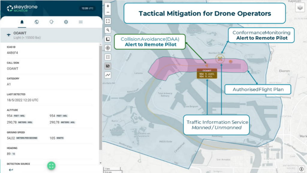
Traffic Information Service

For drone operations beyond visual line of sight (BVLOS), having a clear view of the surrounding air traffic is essential. SkeyDrone’s Traffic Information Service helps drone operators fly with confidence by giving them a real‑time picture of what’s happening in the air around them.
By combining multiple sources such as radar data and SkeyDrone’s detection network, our traffic information service provides unparalleled situational awareness. Our cutting-edge software, SkeyDrone Monitor, delivers a comprehensive air picture, displaying both crewed and uncrewed traffic, empowering you to navigate with confidence.
ADLC is using our Traffic Information Service to transport petrochemical samples from a plant in the north of Antwerp to a laboratory 14 km south, partially entering the controlled airspace of Antwerp Airport.
SkeyDrone Monitor
- Visualisation of live traffic, fused from different sources
- Display of non-cooperative uncrewed traffic
- AIS integration
- Intrusion alerts for self-definable zones
- Flight plan conformance monitoring
- Loss of separation detection
To learn more about our Traffic Information Service, download the solution sheet or read the ADLC case study.
SkeyDrone conducted the first BVLOS flight in controlled airspace around Brussels Airport, all while the airspace remained active for crewed aviation!
The drone took off from the 12th floor of the Living Tomorrow campus in Vilvoorde and was remotely operated from our control room 13 km away. This achievement marks a significant step forward in integrating drones safely into complex airspace.
Read More
- Best-in-class Traffic Information Service: A game changer for BVLOS Drone Operations
- First Drone Flight with Active Deconfliction in Controlled Airspace around Brussels Airport
- SkeyDrone and SafeSky Exchange Traffic Data to Enhance Safety in the Skies
- Successful BVLOS Drone Flight Between Residential Care Center and General Hospital